
Climate of Himachal Pradesh
- The climate varies across the state with the altitude. In the southern low tracks between an altitude of 400-900 it is hot sub humid type, between 900-1800m altitude warm & temperate, between 900-2400m cool & temperate, cold alpine & glacial above 2400- 4800m altitude. Bilaspur, Kangra, Mandi, Sirmour, and Una districts experience sub tropical monsoon, mild and dry winter and hot summer.
- Shimla district has tropical upland type climate with mild and dry winter and short warm summer. Chamba district experiences, humid subtropical type climate having mild winter, long hot summer and moist all season.
- Kullu district experience mainly humid subtropical type of climate with mild winter moist all season, long hot summer and marine.
- During the period from January to February heavy snowfall in higher reaches create conditions for low temperature throughout the state making it unpleasant and series of western disturbances also affect the state

- Himachal Pradesh can be divided into three regions: –
- The Shivalik ranges (the height from plain upto 915 metres);
- Colder Zone (the height is about 4500 metres); and
- The Axis and Crystalline core of the whole system (the height above 4500 metres but below 5500 metres).
- The climatic conditions, therefore, vary from the semi- tropical to semi-artic. Physiographically, the state can be divided into five zones based on altitudes and moisture regime conditions.
- These vary from wet humid sub-temperate situation to dry temperate alpine high lands. Besides the seasonal variations, the climate of Himachal Pradesh varies at different altitudes. The average rainfall is 152 cms. (60 inches). The highest rainfall occurs in Kangra district followed by Shimla district.
Temperature of Himachal Pradesh
- There are striking variations in the mean annual temperature in the state. Mean annual temperature is higher in western parts of the state and it decreases gradually towards north and eastern parts, as the altitude increases. The maximum mean annual temperature of above 25 degree Centigrade is recorded in the southern and western part of Una district, the western parts of Bilaspur district, and the extreme southwestern part of Solan district.
- The average annual temperature lies between 20 and 25 degree Centigrade in the remaining parts of Una and Bilaspur districts, the northwestern part of Solan district, parts of Hamirpur district, and the extreme western part of Mandi district.
- In the eastern parts of Mandi district, parts of Kullu district, Kangra valley area, and the northeastern part of Solan district, the variation in mean annual temperature is between 15 and 20 degree Centigrade.
- In the remaining parts of the state, the mean annual temperature is less than 15 degree Centigrade.
- Temperature in general decreases from south to north. The average monthly temperature of the summer months varies from 26 C in the lower outer valleys to 14 degree Centigrade in the inner valley zone, and that of winter months from 13 degree Centigrade to 4 degree Centigrade.
- Temperature also decreases with increasing altitude.
Rainfall Pattern in Himachal Pradesh
- Most of the rainfall in Himachal Pradesh originates from the southwestern monsoon, starting in June and stretching up to September.
- Maximum rainfall occurs during the months of July and August. During winter months, a fairly good amount of rainfall and snowfall is also received from western disturbances throughout the state.
- Spatially, in general, rainfall follows altitudinal patterns and increases from plains to the hills. Due to rain shadow effect of the Dhauladhar and Pir Panjal ranges, rainfall starts decreasing towards Lahaul-Spiti and Kinnaur.
- Spiti valley is closed from all sides by high mountains and therefore it is driest. Rainfall distribution varies from less than 50 mm in the drier part of Lahaul-Spiti and Kinnaur districts to over 3,000 mm in the area around Dharamsala. Dharamsala receives the highest rainfall in the state.
- The peripheral areas of Dharamsala region, the southwestern part of Chamba, and the southern part of Sirmaur receive annual rainfall above 2,000 mm.
- From these regions, the rainfall declines gradually towards the northern and eastern parts of the state.
- In the central, southwestern and southeastern parts of the state, rainfall ranges between 1,000 and 2,000 mm.
- In the northwestern and eastern parts of Chamba, the south-western portion of Lahaul-Spiti, the southern and western parts of Kinnaur, and parts of eastern Kullu, the annual rainfall varies between 50 and 100 mm.
Drought in Himachal Pradesh
- Meteorological drought over an area is defined as a situation when the monsoon seasonal (June-September) rainfall over the area is less than 75% of its long-term average value. Moderate drought: if the rainfall deficit is 26-50% and Severe drought: when the deficit exceeds 50% of the normal.
- A year is considered as a ‘drought year’ when the area affected by moderate and severe drought either individually or together is 20- 40% of the total area of the country and seasonal rainfall deficiency during southwest monsoon season for the country as a whole is at least 10% or more.
- Himachal Pradesh is enlisted under the frequent drought (10-20% probability) prone areas as per Indian Meteorological Department’s (IMD) classification of drought incidences from 1875-2004 periods.
- A total of 23 droughts have occurred in the state of which 20 were moderate and 3 have been severe over the 1879-2009 time periods with the drought probability of 17 % and with four instances of consecutive droughts over two years.
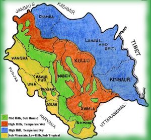
Agro climatic Zone of Climate of Himachal Pradesh
SHIVALIK HILL ZONE Climate of Himachal Pradesh:
- Climate Sub Tropical, consists of foothills and valley area from 350 to 650 meters above mean sea level.
- It occupies about 35% of the geographical area and about 40% of the cultivated area of the State.
- The major crops grown in this Zone are Wheat, Maize, Paddy, Gram, Sugarcane, Mustard, Potato, Vegetables etc.
MID HILL ZONE Climate of Himachal Pradesh:
- This zone extends from 651 meters to 1,800 meters above mean sea level. Having mild temperate climate.
- It occupies about 32% of the total geographical area and about 37% of the cultivated area of the State.
- The major crops are Wheat, Maize, Barley, Black Gram, Beans, Paddy etc. This zone has very good potential for the cultivation of cash crops like Off-Season Vegetables, Ginger and production of quality seeds of temperate vegetables like Cauliflower and root crops.
HIGH HILL ZONE Climate of Himachal Pradesh:
- It lies from 1,801 to 2,200 meters above sea level with humid temperate climate and alpine pastures.
- This zone covers about 35% of the geographical areas and about 21% of the cultivated area of the State.
- The commonly grown crops are Wheat, Barley, Lesser Millets, Pseudo-cereals (Buckwheat and Amaranthus), Maize and Potato etc.
- The area is ideally suited for the production of quality seed Potato and temperate Vegetables. This zone possesses good pastures and meadows.
COLD DRY ZONE Climate of Himachal Pradesh:
- It Comprises of Lahaul-Spiti and Kinnaur Districts and Pangi Tehsil of Chamba District lying about 2,200 meters above mean sea level.
- It occupies about 8% of the geographical and 2% of the total cultivated area of the State.
- The major crops grown are Wheat,Barley, Pseudo-cereals like Buck wheat and Amaranthus. It is ideally suited for the production of quality Seed Potato, temperate and European type of Vegetables and their Seeds, Seed Potato, Peas as green and seed purposes.
[/lockercat]HPPCS Notes brings Prelims and Mains programs for HPPCS Prelims and HPPCS Mains Exam preparation. Various Programs initiated by HPPCS Notes are as follows:-
- HPPCS Mains Tests and Notes Program
- HPPCS Prelims Exam - Test Series and Notes Program
- HPPCS Prelims and Mains Tests Series and Notes Program
- HPPCS Detailed Complete Prelims Notes