Geographical location of Himachal Pradesh
- Himachal Pradesh is situated between 30 degree 22′ 40” to 33 degree 12’ 20” north latitudes and 75 degree 45′ 55″ to 79 degree 04’ 20” east longitudes.
- Himachal Pradesh is predominantly a mountainous State located in North – West India. It shares an international border with China.
- The altitude in the Pradesh, a wholly mountainous region in the lap of Himalayas, ranges from 350 metres to 6975 metres above mean sea level.
- It is surrounded by Jammu and Kashmir in the north, Tibet on north east, Uttaranchal in the east/south east; Haryana in south and Punjab in south west/west.
- The State has highly dissected mountain ranges interspersed with deep gorges and valleys.
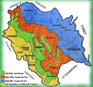
- It is also characterized with diverse climate that varies from semi tropical in lower hills, to semi arctic in the cold deserts areas of Spiti and Kinnaur.
- Altitude ranges from 350 meters to 6975 meters above mean sea level.
- The state is compact in shape and almost wholly mountainous, with altitude varying from 300 m in plains of Kangra and Una to nearly 7,000 m in Central Himalayan range of Lahaul and Spiti.
- It covers a geographical area of 55,673 km2 , which is about 1.69 % of India’s total area.
Geology and Geomorphology:-
- Himachal Pradesh with its complex geological structures presents a complicated topography with intricate mosaic of mountains ranges, hills and valleys.
- Composed of recent Alluvium, Shiwalik hills are made up of rocks su
 ch as sandstone, shale and clay that came into existence during the Eocene, Miocene and Pliocene period.
 - The central part that extends from Chamba district in the north to Shimla district in the south is mainly represented by Jatog group of rocks which originated in middle Proterozoic period.
- In the north eastern portion unclassified Granites borders the central part in between Kullu, eastern Shimla, LahaulSpiti and parts of Kinnaur district.
- The eastern greater Himalaya presents the Triassic formation which is found in Kaza tehsil of LahaulSpiti district.
- The oldest rocks are Granites found at Jeori-Wangtu and Bandel near Largi in Kullu district.
- These granites date back to a stage of the crust at a time when India was located 8000 Km southwest of its present position.
Geographical Location of Himachal Pradesh
Districts
- Himachal Pradesh is built with 12 separate districts.
- They are Shimla, Kangra, Hamirpur, Mandi, Bilaspur, Una, Chamba, Lahul and Spiti, Sirmaur, Kullu, Solan and Kinnaur.
- Among them Shimla district is the capital of Himachal Pradesh.
- The administrative of a district is controlled by a Deputy Commissioner or a District Magistrate who is an officer belonging to the Indian Administrative Service.
- Each district is subdivided into several Sub-Divisions which are controlled by sub-divisional magistrate.
- Every subdivision is built with a number of Blocks and a block is built by several panchayats and municipalities.
| Districts (12) | Area (sq km) | Head quarter | Population |
| Bilaspur | 1,167 sq km | Bilaspur | 382,056 |
| Chamba | 6,528 sq km | Chamba | 518,844 |
| Hamirpur | 1,118 sq km | Hamirpur | 454,293 |
| Kangra | 5,739 sq km | Dharamsala | 1,507,223 |
| Kinnaur | 6,401 sq km | Reckong Peo | 84,298 |
| Kullu | 5,503 sq km | Kullu | 437,474 |
| Lahaul & Spiti | 13,835 sq km | Keylong | 31,528 |
| Mandi | 3,950 sq km | Mandi | 999,518 |
| Shimla | 5,131 sq km | Shimla | 813,384 |
| Sirmaur | 2,825 sq km | Nahan | 530,164 |
| Solan | 1,936 sq km | Solan | 576,670 |
| Una | 1,540 sq km | Una | 521,057 |
Some Facts about Geographical location of Himachal Pradesh
- Altitude above Sea Level: 350 m to 6975 m
- Average Rainfall: 1469 mm
- Geographical Area: 55,673 sq. km
- Temperature: Maximum Temperature – 35o Celsius
- Minimum Temperature – 2o Celsius
- Location: It extends from 30o22′ N to 33 o12′ N and 75 o45′ E to 79 o04′ E
- Major Languages Spoken: Hindi, Local Dialects
- Major Religions: Hinduism, Islam, Christianity, Buddhism
- Major Rivers: River Sutlej, River Beas, River Ravi and River Parbati
- State Animal: Snow Leopard
- State Bird: Western Tragopan (Jujurana)
- State Flower: Pink Rhododendron (gulabi Buransh)
- State Tree: Deodar
- State Capital: Shimla
- WillLife Sanctuaries: 32
- Important Cities: Chamba, Dalhousie, Kangra, Dharamsala, Palampur, Hamirpur, Una, Solan, Nahan, Shimla, Mandi, Kullu and Manali