
Relief and Structure of Himachal Pradesh
- The area covered by Himachal Pradesh lies in most complicated geological regions of
- Outer or sub-Himalayan zone,
- Lower Himalayan zone,
- Higher Himalayan zone,
- Tethys Himalayan zone.
- The highest relative relief (more than 5,100 m) is found in the eastern part of the state, covering the western part of Kinnaur, the northeastern margin of Shimla, and the southeastern extreme of Kullu districts.
- In the peripheral area of this belt, a very narrow belt showing high relative relief (between 3,400 and 4,200 m) is noticeable.
- Another belt of high relative relief (between 2,400 and 3,300 m) extends over the state from north to southeast direction and it includes the northeastern part of Chamba, Bara Bhangal area of Kangra, western and southwestern portions of Lahaul and Spiti, eastern part of Shimla, and major portions of Kinnaur and Kullu districts.
- In the northwestern portion of the state, the relative relief is mainly between 2,000 and 2,700 m. In the northern, central, and southeastern parts of the state, the value of relative relief ranges between 1,300 and 2,000 m.
- The areas with comparatively low relative relief, between 600 and 1,300 m, are the northwestern and central parts of Kangra, the eastern portion of Hamirpur and Bilaspur districts, the most part of Mandi, the entire Solan district, the western and central portions of Shimla district, and the northwestern and central parts of Sirmaur district. Relative relief less than 600 m is found in the western and southern margins of the state.
- Located entirely in the western Himalaya, Himachal Pradesh not only has diversity in relief features but also in slope of the land.
- Nearly 70 % of the state area is covered by steep to very steep sloping land, about 19 % is covered by moderate to moderately steep slope, and only about 11 % is covered by gentle to nearly level slopes. A
- lmost the entire districts of Lahaul and Spiti and Kinnaur (except a narrow strip along the rivers) have rock outcrops and very steep slopes.
- The district of Chamba, northern Kangra, Kullu and parts of Shimla, and Sirmaur and Solan districts are characterized by steep slopes and moderately steep slopes.
- Moderate sloping land is seen along the river valleys in the Kullu and Shimla districts. Level to gentle sloping land is limited to the southern Kangra and parts of Mandi district, the dun valleys of Una, Hamirpur, Bilaspur, Solan and Sirmaur districts.
Topography of Relief and Structure of Himachal Pradesh
- On the basis of elevation and slope, geographers have grouped Himachal Pradesh into three distinct topographical regions. These are:
- Shiwalik Hills,
- Mountains— Lesser Himalaya, Greater Himalaya and Trans Himalaya,
- Valleys—Shiwalik dun valleys, fluvial, and glacio-fluvial valleys, and
- Mountain Passes.
Shiwalik Hills:
- These are the outermost ranges separating Himachal Himalaya from the Punjab plain. The altitude ranges from 600 to 1,200 m.
- These ranges are the youngest of the Himalayan ranges and are made up of tertiary sediments consisting of sand, clay, and boulder conglomerates brought down by the rivers from the main Himalayan ranges situated further north.
- They are composed almost entirely of tertiary and upper tertiary sedimentary river deposits.
- Shiwalik are prone to erosion and their morphology comprises of highly dissected and rugged residual terrain, hogback ridges, earth pillars, rilled eath buttresses of conglomerate formations, talus cones, choe divides and terraces etc.
- The duns or valleys are drained by network of streams and rivers.
- This zone is about 50 km wide in the west and about 80 km wide in Kangra valley and again tapers to smaller width in Nalagarh and Kyarda Duns in east.
- The crest line are known by many names like Hathi Dhar, Sikandar Dhar, Chaumukhi range, Solasinghi Dhar, Ramgarh Dhar, Naina Devi Dhar and Dharti Dhar.
Mountains:
- Deep gorges and V-shaped valleys, abruptly rising bare crags and sharp pyramidal peaks of the Greater Himalaya, which are in contrast to the even crest line of the Shiwalik hills, characterize this zone.
- The mountains of Himachal can be classified in three categories, viz., Lesser Himalaya, Greater Himalaya, and Trans Himalaya.
Lesser Himalaya:
- The Middle or Lesser Himalaya is located north of Shiwalik range.
- They form an intricate and rugged mountain system about 60–80 km wide and 1,000–4,000 m high.
- Several peaks rise to nearly 5,000 m and remain snow covered throughout the year.
- The Lesser Himalaya lies between the “main boundary” and the “central Himalayan” thrusts.
- Most of this zone consists of granite and other crystalline rocks of unfossiliferous sediments.
- Similar to the Shiwalik range, Lesser Himalaya are not a continuous range but consist of a number of smaller ranges like Dhauladhar, Pir Panjal, Churdhar, and Shimla ranges.
- The Dhauladhar and Pir Panjal ranges are conspicuous and quite distinct in the west and form the southern and northern watershed of Ravi Basin.
- Dhauladhar extends further east into the Beas valley and crosses the Satluj river near Rampur.
- Pir Panjal forming the southern watershed of the Chandrabhaga in Chamba and Lahaul Spiti districts joins the Great Himalayan range north of Deo Tibba and Rupi Valley (Parbati River).
- Some minor ranges of lesser Himalaya are Dagni Dhar, Mani Mahesh and Dhog Dhar in the Ravi valley; Jalori Dhar and Shikari Dhar in Beas and Satluj basins and Nagtibba range, Mussourie range and Shimla hills in the Yamuna basin east of the great Himalayan Divide
Great Himalaya or Central Zone
- These are the highest mountain ranges that run across the nort eastern border of himachal through Lahaul Spiti and Kinnaur districts.
- The elevation of the great Himalaya ranges between 5000 and 7000 m, and it has several passes having elevations between 4500m.
- This towering snow-clad mountain wall is a store house of many glaciers and acts as a source of many rivers; it also plays an important role in governing the climatic condition of the state as it acts as a barrier against the northward movement of the southwest monsoon.
- It forms the northern watershed of the Chandrabhaga (Chenab) basin and separates it from Spiti basin and further east it forms watershed between Spiti and Beas basins. It is cut across by Sutlej before it enters the Utter Pradesh Himalaya with extension to Badrinath/Kedarnath.
Trans-Himalaya:
- Beyond the almost inaccessible snow-covered Great Himalayan ranges lies the cold arid region of Kinnaur, Lahaul, and Spiti.
- The trans-Himalayan area of the Spiti valley is composed of continuous series of highly fossiliferous marine residue rocks of earliest Palaeozoic to the Eocene age.
- The average elevation of the Trans-Himalaya is over 3,000 m.
- This region is cold and arid because the monsoon winds cannot reach here because of the lofty Greater Himalayan range. Zanskar range is the most prominent range of the Trans-Himalaya, separating Spiti and Kinnaur from Tibet.
Valleys in Himachal Pradesh:
- The state has number of valleys of various elevations, which are formed by tectonic forces as well as by the work of rivers and glaciers.
- The valleys of Himachal can be grouped into:
- Shiwalik duns,
- Fluvial, glacio-fluvial valleys of outer, inner, and greater Himalaya.
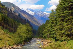
- The Kangra valley is the most prominent valley of the outer Himalaya.
- The Kangra valley is an extensive dun-type valley of tectonic origin located between the Dhauladhar range in the north and the Shiwalik in the south.

- This beautiful valley extends down the southern slopes of the Dhauladhar range, covered with forests of pines, tea gardens, and terraced fields.
- The valleys at higher elevation are found along the major rivers and their tributaries.
- The major rivers like Beas, Ravi, Chenab, Sutlej, Pabbar etc which originate from glaciers and meanders through these valleys.
- The examples are Kullu valley, Sangla valley, Pin valley, Hangrang valley, Pattan valley, Chamba valley, Pangi valley etc.
Major Mountain Passes in Himachal Pradesh:
Himachal Pradesh, being a hilly state, is bounded on many sides by high hills and there are several inhabited valleys enclosed around by high mountains.
- Kundi ki jot -Kaniara and Chinota of Chamba dist.
- Bohar pass –Boh in Kangra and Basu or Bakan in Chamba.
- Indrar pass —Dharamsala (Kangra district) and Chinota
- Satnalo pass —Bandla (Kangra district) and Bara Bauao.
- Talang pass —In the head of Bangana river, between Narwana or Jiya (Kangra district) and Traita.
- Kuronw and Sultanpur passes –In the mountain ranges of Lahaul and Kullu dist.
- Bara Lacha passes— Lies between Zingzingbar and Lingti encamping grounds (Height is estimated to be between 16221 and 16500 feet)
- Kugti pass —Bara Bhangal tribal area
- Kwagpur pass —Between villages of Sungra in Kinnaur and Teri in Spiti
Glaciers in Himachal Pradesh
- There are more than 5,230 glaciers in the Himalaya, out of which nearly 2,550 glaciers are in Himachal Pradesh.
- The glaciers of Himachal hold 387.3 cubic km of ice reserves.
- This much of ice reserves can cater 18 % of fresh water demand of India. Most glaciers in Himachal (945 glaciers) are in the Satluj basin, followed by Chenab and Beas.
- They are natural reservoirs of fresh water which feed the north Indian rivers.
- They are located in altitudes of over 4,000 m above msl in the Pir Panjal, Greater Himalaya, Dhauladhar, and Zanskar ranges.
- A majority of them are small in size, with accumulation zone of 2–4 km2 . They are linear in form, varying in length from 2 to 25 km.
- The major glaciers in Chenab basin are Bara Shigri, Samudra Tapu, Mulkila, Ghhudong, Miyar, Chota Shigri, and Sona Pani.
- The largest four glaciers in Beas basin are Dudhen, Sara Umga, Trichu, and Dibhika.
- The state comes under the environmental influence of glaciers, directly or indirectly.
- Existing glaciers are merely the shrunken remnants of the previously much more extensive alpine glaciers of the Pleistocene ice age.
- Garwood has suggested that in Kangra valley glaciers came down to the elevation as low as 610 m.
- On the basis of analysis of deposits found in the Kangra valley, Sharma maintained that this area has experienced three major glacial phases. Evidences bearing the presence of glaciers in the past in the form of moraines, ice transported blocks, smoothened and striated rock surfaces, U-shaped valleys, hanging valleys, glacial lakes and glacial- fluvial deposits are preserved in different parts of the state.
- Evidences of glacier recession in the present day are obvious. Various governmental and non-governmental organisations e.g. Geological Survey of India, Luknow in their study on “Glacier recession in Himalayas”; Dr. Kulkarni and associates from Marine and Water Resources Group, Space Applications Centre, Ahmedabad (2002), have studied the effects of climatic variations on snow and glaciers in the Himachal Himalaya.
- HPPCS Mains Tests and Notes Program
- HPPCS Prelims Exam - Test Series and Notes Program
- HPPCS Prelims and Mains Tests Series and Notes Program
- HPPCS Detailed Complete Prelims Notes